Gravel management in Southland
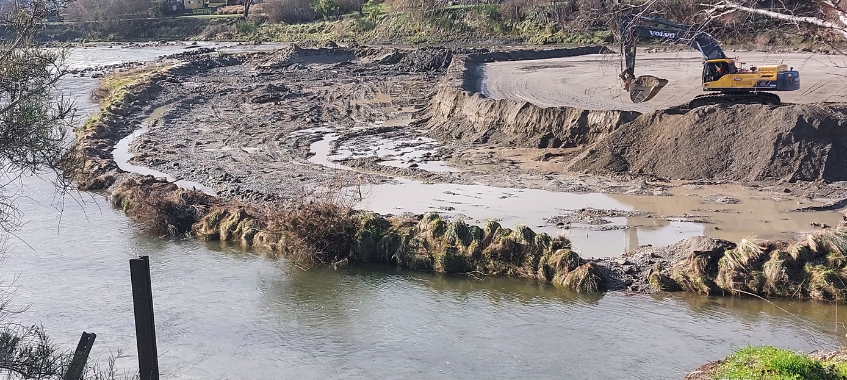
Gravel build-up being removed on the Mataura River - 40,370 tonnes were extracted from the site and used in the construction of the Ontario Street flood bank in Gore.
Managing river gravel is part of Environment Southland’s wider river management programme
In Murihiku Southland, gravel management involves a range of parties with different — and valid — perspectives. In some places, gravel build-up can increase flood and erosion risk and damage infrastructure; in others, gravel provides important habitat for aquatic species and birds. A balanced approach is needed. Alongside localised build-ups, we also see gravel deficits in the lower reaches of some rivers, particularly the Ōreti River.
A more holistic approach to river management is key to better environmental outcomes and will take time to achieve. In the short term, targeted measures can support gravel management at specific locations (for example, monitoring and redistribution, maintenance around structures, or consented extraction where appropriate).
A collaborative approach
Environment Southland is collaborating with stakeholders and the public to build a collective approach to flood risk, edge protection and gravel management. To inform the discussion, Environment Southland is gathering the necessary science and technical information, using new technology to build a clearer picture and to inform our future decisions. A key aspect is understanding the volume and distribution of gravel in Southland rivers (the gravel budget) as part of a broader floodplain management approach.
Southland Gravel Working Group (SGWG)
The Group met several times during 2024 and early 2025 and has worked to clarify the gravel problem definition, discussed science-led gravel management, and created a roadmap toward a solution. The Group has worked with the Southland Technical Advisory Group (STAG) on case studies around a range of options and outcomes.
SGWG outcomes
- A clear gravel management problem definition.
- An explanation of 'good' gravel management practices for Murihiku Southland, ideally using the science-led principles in the Towards Strategic Gravel Management working document (see below).
- Identification of ‘the gap’ between current practices and the desired future state.
- The SGWG will consider information and feedback received from the stakeholders and community meetings. This will be provided as written notes.
- Feedback on the long-term approach and possible further opportunities to collaborate.
- Clear short-term pathway for the following steps to achieve operational certainty in gravel management.
Rules for gravel removal from rivers clarified
There are instances where permitted activities exist, and where they don’t, we are working through this process. It doesn’t mean gravel is not being extracted. We have granted an average of 150 gravel consents per year over the past 12 years, and extracted hundreds of thousands of cubic metres each year.
Environment Southland has recently provided clarity to structure owners on the rules governing gravel removal from rivers.
We have written to the city and district councils, KiwiRail and the New Zealand Transport Agency to explain the rules in the Southland Water and Land Plan that apply to gravel extraction around structures in rivers, like bridges. Under the rules, gravel can be removed to support the maintenance of structures without resource consent, provided certain conditions are met. It also confirms Environment Southland’s approach to written approvals for resource consents.
Science-based decision-making
Towards Strategic Gravel Management
Towards Strategic Gravel Management is a technical working report to inform the discussion on Southland’s gravel management approach. It outlines a series of scientifically led strategic principles and recommendations that should underpin and inform gravel management in Southland’s rivers.
Report - Towards Strategic Gravel Management, Dr Ian Fuller
The report makes several suggestions which we are progressing:
Recommendation | Environment Southland actions |
The need for reliable information on the gravel load of Southland’s rivers to create gravel budgets. | Data gathering for gravel budgets is underway. Additional funding is required and has been requested through the 2024-34 Long-term Plan. |
There is a need for a holistic approach to gravel management. | Environment Southland is transitioning work to have an integrated catchment focus in accordance with our proposed Southland Water and Land Plan. |
Further studies on how channels respond to vegetation lock-up in Southland and further trials assess the viability of using gravel management options intended to ‘unlock’ channels, including bar top (beach) skimming. | The report highlights several trials already carried out by Environment Southland. Further trials are being planned, including a focus on ecological values. |
In the long term, allowing the river room to erode will increase the geomorphic and habitat diversity in the river corridor and improve resilience in the face of increased flood magnitudes. | Floodplain management will create the opportunity to explore options for giving the river more ‘room to move’. |
A collaborative approach to problem-solving. | See above. |
A phased approach is needed, and communities will need time to appreciate and understand the changes in practice. | Staged approaches are being planned for freshwater and floodplain management plans. Community engagement is fundamental to this approach, and Environment Southland is committed to working with the community to identify and implement solutions. |
Technology is helping build a clearer picture
We are using the latest technology to improve our understanding and that of our community.
Environment Southland has completed a resource assessment using bathymetric LiDAR (Light Detection and Ranging) surveying along the length of the Mataura, Ōreti and Aparima rivers. This uses water-penetrating light to measure seafloor and riverbed elevations. Data collection for this project is complete, and data processing is underway. LiDAR elevation mapping is also nearing completion, with the lower Mataura, Aparima, Ōreti and Rakiura areas already available. Read more about the Aparima and Ōreti work here.
Waikaia farmers and others discuss the Waikaia River’s path during a field day
Among their many functions, the maps help further understand landscape changes and catchments’ hydrological processes, such as stream flow estimation and catchment size. This includes locating gravel build-up in rivers. Two web applications have also been created for people to view and use both the LiDAR data, and the 2023 rural and urban imagery collection. These datasets cover the majority of Murihiku Southland, with more being added as they become available. They can be found here and here.
Among work related to this is the ‘Murihiku Slow the Flow’, a collaborative pilot led by Environment Southland in partnership with Ngāi Tahu Kā Rūnanga ki Murihiku. Together, we’re exploring how nature-based solutions can help reduce flood risk, build community resilience and improve the health of our land and water – read more here.
Smaller floods causing gravel build-ups
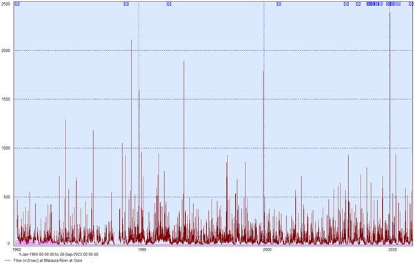
Larger flooding events naturally move more gravel, and over the past 20 years, Murihiku Southland has experienced fewer such events. Smaller floods tend to disperse sediment across gravel bars without moving the gravel. This can make the gravel bars suitable for weed and vegetation growth, and we see more root mats and stems forming, making the gravel more resistant to river flows. The quality of the gravel can also be affected by silt.
Earth Sciences New Zealand (formerly NIWA) has indicated that maximum daily rainfall totals are projected to rise across the various climate change scenarios outlined by the Intergovernmental Panel on Climate Change, leading to increased river flows and flood magnitudes. This presents a greater risk for our communities.
Note - It’s best illustrated in a graph. You can see a lack of large events from 2000 to 2020 on the Mataura River.
Working together for flood-risk reduction
Environment Southland works with Gore District Council, Invercargill City Council, Southland District Council, and Te Ao Mārama Inc. (on behalf of Ngāi Tahu ki Murihiku) to respond to climate change and manage river systems across the region.
Gravel management is a shared responsibility. Environment Southland is not the only authority involved. Territorial authorities and infrastructure owners also undertake gravel work during maintenance of assets such as bridges.
Learn more about our wider climate and flood-risk-reduction work:
- Flood Resilience Programme — upgrades, renewals and planning across priority catchments.
- Murihiku Slow the Flow (pilot) — bringing technical, cultural and place-based knowledge together to assess the potential for nature-based solutions to reduce flood risk and improve catchment-wide environmental wellbeing.
- Flood Modelling in Southland — how we use data and models to inform flood infrastructure works and local decision-making.
If you have questions about gravel management in Murihiku Southland, please contact us on 0800 76 88 45 or email service@es.govt.nz.